
Gold Exploration
Project Overview
The Company’s Project is located largely enveloped by tenements held by its major shareholder and previous joint venture partner, St Ives. The St Ives gold operations have run continuously since inception when still part of the then WMC owned Kambalda Nickel Operations in 1980, with the first gold mined at Kambalda/St Ives being specimen stone at the Fisher, Hunt and Lunnon Nickel mines to the immediate south of the Kambalda township followed by recognition of gold mineralisation in the Victory, Orchin and Ives Reward areas on the south side of Lake Lefroy.
The Company’s Project is located largely enveloped by tenements held by its major shareholder and previous joint venture partner, St Ives. The St Ives gold operations have run continuously since inception when still part of the then WMC owned Kambalda Nickel Operations in 1980, with the first gold mined at Kambalda/St Ives being specimen stone at the Fisher, Hunt and Lunnon Nickel mines to the immediate south of the Kambalda township followed by recognition of gold mineralisation in the Victory, Orchin and Ives Reward areas on the south side of Lake Lefroy.
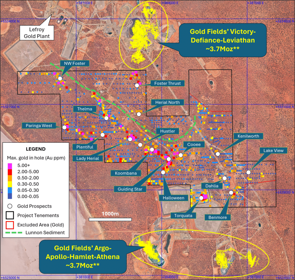
Open pit mining commenced at the Victory complex in 1981, just 1,500 metres north of the Project’s boundary, moving to underground development of the Victory-Defiance system shortly thereafter. The deeper parts of this underground mine, termed Conqueror, are less than 250 metres to the north of the Project.
In 1987 a dedicated gold processing facility was commissioned in the locality of the Company’s Jan Shaft Nickel Mine and called St Ives, whilst following purchase of the assets from WMC in 2001, Gold Fields Ltd built a new 4.8 mtpa facility to the north of the Project on the south shore of Lake Lefroy in 2005, termed the Lefroy Plant.
Gold discoveries continued to occur throughout the district and to the immediate south of the Project the Argo-Apollo-Hamlet-Athena camp of gold deposits evolved from first discovery in 1994 (Argo) through to the present day with Hamlet underground continuing in production.
The area has benefited from extensive prior geophysical surveys allowing the Company’s technical staff to complete a detailed review and analysis of the litho-structural framework that hosts both the nickel and the gold mineralisation, based on this holistic view of the comprehensive database coupled with their own direct personal experience on the Project and at St Ives. As a consequence, the Company has now been able to generate new surficial gold anomalism in its exploration work, during the period prior to IPO and compiled a portfolio of empirical and conceptual targets that it considers warrant aggressive testing.
Foster Gap
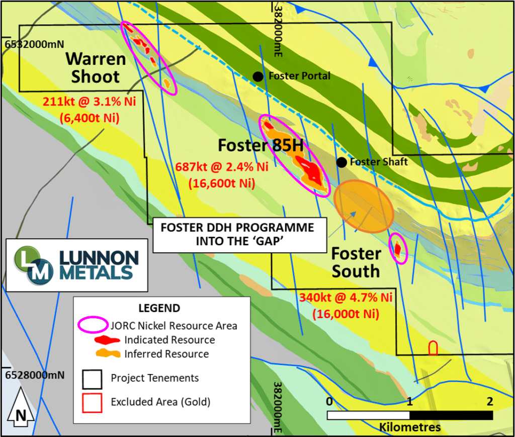
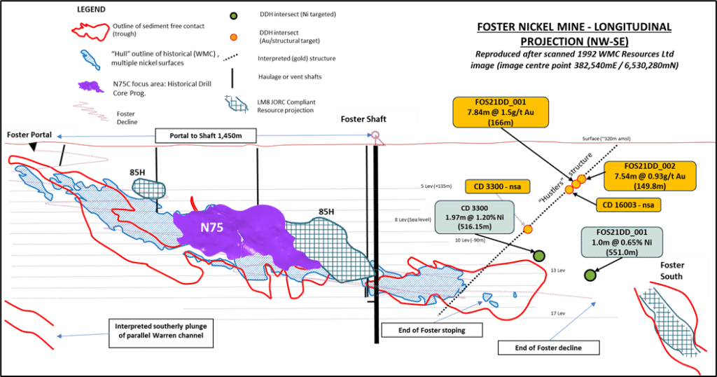
As part of the first diamond drilling campaign, two holes were planned and drilled targeting nickel in the approximate 500m “gap” above and between the end of the Foster Decline and the current 16,000 tonnes of nickel metal in JORC 2012 compliant Mineral Resource at Foster South. Drill hole orientations and depths were designed to accommodate a “watching brief” for potential gold structures, primarily in relation to the possible disruption of the prospective komatiite-basalt nickel contact that these structures may have had given that they “postdate”, or are more recent than, the nickel mineralisation.
Assay results from that first drill program in October 2021 hole identified a previously unrecognised structure, now termed Hustlers, which is considered significant:
Other intersections of note in the program were:
CD3300
8.58m @ 1.05 g/t Au (112.1m)
0.64m @ 2.88 g/t Au (125.8m)
0.91m @ 2.01 g/t Au (386.84m)
Did not intersect any significant assays on Hustlers structure
FOS21DD_002
0.3m @ 19.48 g/t Au (162.4m)
0.87m @ 2.45 g/t Au (168.65m)
FOS21DD_001
1.0m @ 1.89 g/t Au (656m)
1.0m @ 1.49 g/t Au (676m)
The close association between nickel and gold at the Kambalda/St Ives camp is well documented. Total historical production of nickel and gold across the entire district is estimated to be approaching 1.6 Mt of nickel metal and now over 15 Moz of gold.
A previously unrecognised structure has now been defined over an area of at least 300m down dip and 150m across strike by four separate diamond holes. Given the intersection points on this new structure, it has been possible to extrapolate the structure to the north-west and down dip to evaluate its potential impact on the prospective nickel contact.
The below image, Foster Nickel Mine – Longitudinal Projection shows the relevant area of the Foster Mine illustrating the location and elevation of the four intersection points on this new structure, the pierce point of the two diamond holes that continued on to intersect the prospective nickel contact and the interpreted position of the structure on the plane of projection.
The projection of this structure appears to coincide with a structure identified in the historical underground mapping which terminates the nickel bearing shoots in that part of the Foster Mine workings, supporting the Company’s view that developing a robust model for these later structures will be an important tool in the programme to extend the known nickel Mineral Resource as well as possible discoveries of new zones of nickel mineralisation.
In relation to the direct test of the komatiite-basalt contact for the presence of economic nickel mineralisation, FOS21DD_001 and CD 3300 (extended) both intersected the prospective komatiite-basalt contact close to or at the planned depths.
Sign Up for ASX Alerts and News to receive the latest updates, insights, and developments directly to your inbox.